My Store
French Map Malta 1718 Henri Michelot Laurent Bremont - Nouvelle Carte Isle Malthe
French Map Malta 1718 Henri Michelot Laurent Bremont - Nouvelle Carte Isle Malthe
Couldn't load pickup availability
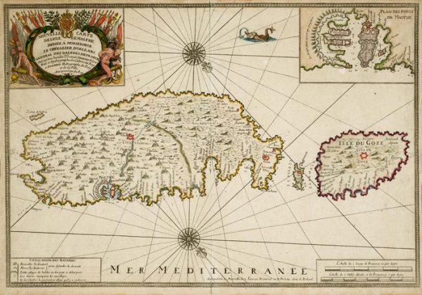
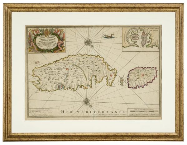
A Beautiful French Map Titled 'Nouvelle Carte De L'isle De Malthe' by Henri Michelot, Laurent Bremont Dedicated to Chev. Jean Philippe d'Orleans (1718)
An exceptional and museum-quality French copper engraving map of Malta from 1718, titled 'Nouvelle Carte De L'isle De Malthe' (New Map of the Island of Malta), created by the distinguished cartographers Henri Michelot and Laurent Bremont. This magnificent map is dedicated to Chevalier Jean Philippe d'Orléans, connecting it to French royal patronage and the highest levels of 18th-century society. The map depicts Malta, Gozo, and Comino with remarkable detail, showing fortifications, harbors, towns, and geographical features during the Knights of St. John period. This historically significant cartographic work offers collectors an opportunity to acquire an authentic 18th-century map of exceptional beauty, historical importance, and investment value.
Henri Michelot and Laurent Bremont - Master Cartographers
Henri Michelot and Laurent Bremont were distinguished French cartographers and hydrographers working in the early 18th century, particularly known for their maritime charts and maps of the Mediterranean. Their work combined scientific accuracy with artistic beauty, creating maps that served both practical navigation purposes and decorative functions. Maps by Michelot and Bremont are highly sought after by collectors of antique cartography, Mediterranean history, and French decorative arts. Their collaboration on this Malta map represents the high standards of French cartography during the Regency period.
1718 Dating - Historical Context
The 1718 date places this map during the Regency period in France (1715-1723) when Philippe II, Duke of Orléans, served as regent for the young Louis XV. This was a period of French cultural flowering and renewed interest in Mediterranean affairs. For Malta, 1718 fell during the Knights of St. John's rule (1530-1798), after the Great Siege of 1565 and the construction of Valletta, but before the Order's decline in the later 18th century. The map documents Malta at a crucial historical moment, showing the island's fortifications, harbors, and settlements as they appeared over 300 years ago.
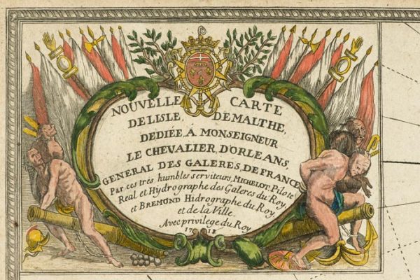
Dedication to Chevalier Jean Philippe d'Orléans
The map's dedication to Chevalier Jean Philippe d'Orléans (1702-1748), known as the Chevalier d'Orléans, connects it to French royal family and the highest levels of aristocratic society. Jean Philippe was the illegitimate son of Philippe II, Duke of Orléans (the Regent), and was raised at court with royal privileges. Dedications to such prominent figures enhanced maps' prestige and often indicated patronage relationships. This royal connection adds significant historical interest and provenance to the map, documenting the intersection of cartography, politics, and aristocratic culture in early 18th-century France.
'Nouvelle Carte De L'isle De Malthe' - Comprehensive Cartography
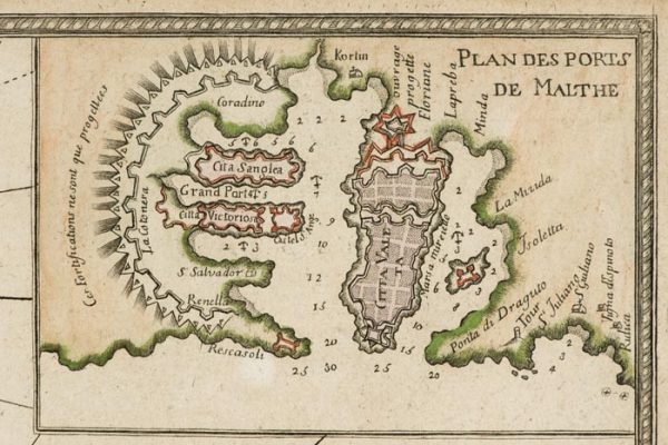
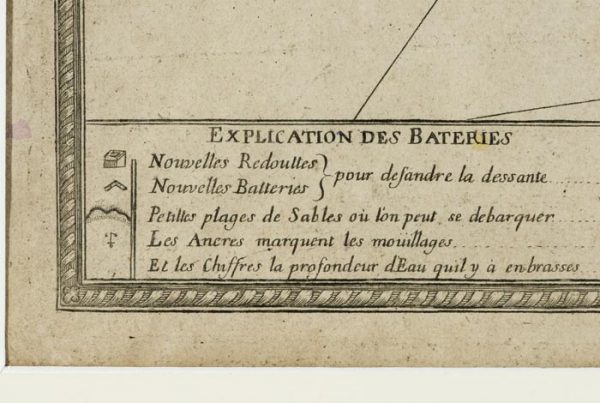
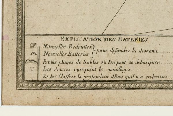
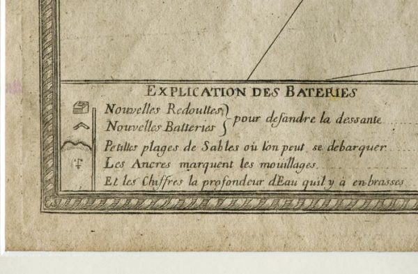
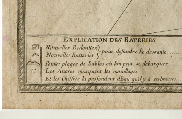
The map's title 'Nouvelle Carte De L'isle De Malthe' (New Map of the Island of Malta) indicates it represented current cartographic knowledge of Malta in 1718. The map depicts Malta, Gozo, and Comino with their fortifications, harbors (particularly the Grand Harbour and its Three Cities), towns, geographical features, and surrounding waters. The level of detail reflects both the cartographers' access to reliable sources and Malta's strategic importance in Mediterranean affairs. The map would have served both practical purposes (navigation, military planning) and decorative functions in aristocratic libraries and studies.
Copper Engraving on Wove Paper - Technical Excellence
Executed as copper engraving on wove paper, this map demonstrates the finest cartographic printing techniques of the early 18th century. Copper engraving allowed for extraordinary detail, fine lines, and the crisp text essential for readable maps. The process involved incising the map's design into copper plates, inking the plates, and printing under pressure onto quality paper. Wove paper, introduced in the early 18th century, provided smooth, even surface ideal for detailed printing. The combination of copper engraving and quality paper ensures this map's clarity, beauty, and durability over three centuries.
Cartographic Details and Features
The map likely includes characteristic 18th-century cartographic elements: decorative cartouche containing the title and dedication, compass rose indicating directions, scale bar for measuring distances, detailed coastlines showing bays and harbors, fortification plans of Valletta and the Three Cities, town locations, geographical features, and possibly decorative elements like ships or sea monsters. These features combine scientific information with artistic beauty, creating maps that functioned as both practical tools and decorative objects worthy of display in aristocratic interiors.
Malta Under the Knights of St. John
This map documents Malta during the Knights of St. John's rule, showing the island's transformation into a fortified Mediterranean stronghold. The detailed depiction of fortifications reflects Malta's strategic importance and the Knights' massive investment in defensive works following the Great Siege of 1565. The map captures Malta at the height of the Knights' power, before the Order's decline in the later 18th century and eventual expulsion by Napoleon in 1798. For historians and collectors of Melitensia, this map provides invaluable documentation of 18th-century Malta.
French Interest in Malta
The map's French origin reflects France's longstanding interest in Malta and the Mediterranean. Many Knights of St. John were French nobles, and France maintained close ties with the Order. French cartographers' attention to Malta indicates the island's perceived strategic and commercial importance. This map represents the intersection of French cartographic excellence, Mediterranean geopolitics, and aristocratic patronage that characterized early 18th-century European culture.
Condition and Preservation
As a map over 300 years old, condition is paramount to value. Antique maps may show age-related characteristics - toning, foxing, marginal tears, or fold lines - that add character while not significantly affecting display quality. Professional conservation can address condition issues while preserving the map's authenticity. The map should be examined for any significant damage, repairs, or alterations. Detailed condition reports available to serious collectors. Proper framing with acid-free materials and UV-protective glazing essential for long-term preservation.
Investment Value and Collectibility
Early 18th-century maps of Malta by documented cartographers with royal dedications represent exceptional investment opportunities. The combination of 1718 date, Michelot and Bremont attribution, dedication to Chevalier d'Orléans, and Malta's enduring collector interest creates strong appeal among collectors of antique maps, Melitensia, French decorative arts, and Mediterranean history. As authentic period maps become scarcer and appreciation for historical cartography grows, quality examples show consistent market performance. Maps with royal connections command particular premiums.
Melitensia - Maltese Cultural Heritage
For collectors of Melitensia - materials relating to Malta's history, culture, and heritage - this map holds exceptional significance. It documents 18th-century Malta's geography, fortifications, and settlements while representing how Malta was perceived and depicted in European cartography. The map connects to Malta's Knights period, its strategic Mediterranean position, and its place in European consciousness. Owning such a map means possessing tangible link to Malta's rich history and its representation in European culture.
Provenance and Authentication
The map's attribution to Michelot and Bremont, 1718 dating, and dedication to Chevalier d'Orléans should be verified through examination of cartographic references, comparison with documented examples, and expert authentication. Comprehensive provenance research available to serious collectors. Understanding the map's history, previous ownership, and scholarly documentation enhances both historical interest and market value.
Display and Presentation
This map deserves professional framing that protects while showcasing its beauty. Acid-free mats, UV-protective glazing, and proper mounting techniques preserve the map while enhancing visual impact. The framing should complement the map's 18th-century character while meeting conservation standards. Properly framed, this map creates stunning focal point in libraries, studies, offices, or any space where its historical significance and aesthetic beauty can be appreciated. Professional framing consultation available.
Historical and Cultural Significance
This map embodies early 18th-century French cartography, Malta's Knights period, aristocratic patronage of the arts and sciences, and the European fascination with Mediterranean geography and history. It represents the intersection of scientific knowledge, artistic skill, political connections, and cultural interests that characterized Enlightenment-era Europe. The map documents not just Malta's geography but also how the island was understood and represented in European consciousness.
Collecting Context
This map appeals to collectors of antique cartography, Melitensia, French decorative arts, Knights of St. John history, Mediterranean studies, and those seeking historically significant works with royal connections. It would enhance private collections, corporate holdings, institutional acquisitions, or serve as centerpiece in collections focused on Malta, Mediterranean history, or 18th-century cartography.
Available for viewing by appointment at Artemisia Fine Arts & Antiques Ltd, Malta's premier gallery for historical Melitensia and antique maps. We provide expert consultation, authentication services, conservation coordination, framing recommendations, insurance valuation, and international shipping with specialized map handlers. This exceptional 1718 French map with royal dedication represents a once-in-a-lifetime acquisition opportunity. Serious inquiries from qualified collectors and institutions welcome.
Share